LIFE-MICACC project
LIFE16 CCA/HU/000115
"Municipalities as integrators and coordinators
in adaptation to climate change"
LIFE-MICACC project
LIFE16 CCA/HU/000115
"Municipalities as integrators and coordinators
in adaptation to climate change"
One of the undertaken commitments of the LIFE-MICACC project is to conduct runoff modelling in pilot sites at the five municipal partners to provide decision makers with accurate input data on adaptation options (for example natural water retention measures) using specific geographic data. It is based on a centimetres accurate measurement and the study of extreme events that will occur more frequently as climate change intensifies. The falling precipitation – and the resulting excess water – knows no settlement borders, so experts do not map such runoff patterns within administrative boundaries. Rather, they are characterized by designating of a catchment area and contacting settlements within it. | 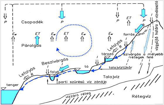 |
The model works with the relief, temperature and precipitation data of the river basins. Further information on this topic is provided by various land cover and soil moisture data, which may also indicate the causes of problems in agricultural areas.
Modelling seeks to answer among other things the following questions:
In addition to providing possible flow directions, runoff models can help identifying the most vulnerable points in a given area, as well as locations, where the water retention measures could be the most effective (be they natural or artificial artefacts). The model is planned to be completed at the third quarter of 2020. The tasks related to runoff modelling within the framework of the LIFE-MICACC project are coordinated by Pannon Pro Innovation Services Ltd., the beneficiary partner of the project. | 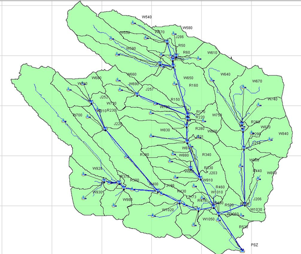 |

|

|

|
|

|

|

|

|

|

|

|

